FJD Dynamics — Authorized Distributor

FJD Trion
LiDAR Scanners

Industrial-grade precision in the field. The Trion P2 and S2 series deliver centimeter-level accuracy, real-time colorized point clouds, and multi-format deliverables for every scale of project.

1cm
Relative Accuracy
70m
Scanning Range
700g
Ultra-Light Body
4H
Battery Runtime
200K
Points / Second
Scroll
Product Overview

Two Scanners. Every Environment.

Whether you need featherlight portability for indoor capture or high-speed air-to-ground coverage for large sites — there's a Trion for the job.

Next Generation FJD Trion P2

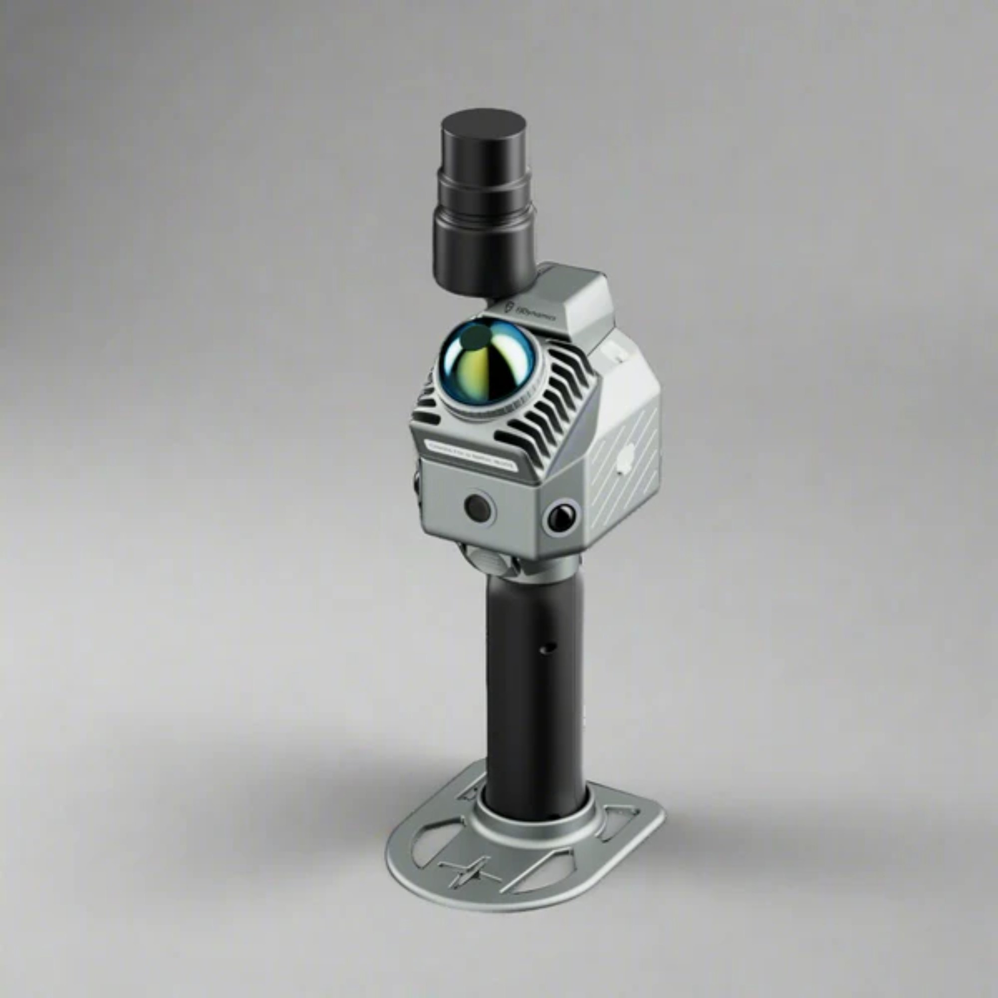
Smaller. Smarter. Scan More.

The FJD Trion P2 combines groundbreaking portability with industrial-grade accuracy. At just 700g, it delivers centimeter-level precision, real-time colorized point clouds, and multi-format deliverables — engineered for professionals, surveyors, and 3D scanning enthusiasts who need more from less.

≤1 cm
Post-processed accuracy
70 m
Range @ 80% reflectivity
700 g
Body weight only
IP54
Dust & water resistance
AI Fusion 🧠
MultiSLAM Fusion

Hybrid LiDAR SLAM + Vision Camera + RTK/PPK constraints eliminate drift in featureless areas — beaches, tunnels, open parks — with consistent, reliable results.

5–7× Denser
HyperDense+ Point Clouds

Upgraded CPU generates real-time colorized clouds with point spacing down to 1mm — delivering 5 to 7× the density of standard capture for superior quality.

📷
Three Built-In Cameras

A 2MP front camera (70° FOV) paired with two 12MP side cameras (280°×149°) enables true-color point clouds and visual SLAM without any external hardware.

🛰️
Full GNSS & RTK/PPK

Standard RTK setup supporting BDS, GPS, GLONASS, Galileo, and QZSS. Achieves H: 8mm + 1ppm and V: 15mm + 1ppm RMS at 10Hz positioning rate.

Fast Charge 🔋
Dual-Battery System

Simultaneous dual-battery charging via 67W Type-C fast charge. Metal base for rugged durability with 5/8" standard interface for pole mounting.

📶
Triple Data Transfer

Flexible connectivity via USB Type-C, USB Flash Disk, or Wireless Network. Point cloud export in .las / .ply / .pts / .e57 formats.

3 Variants FJD Trion S2

Built for Large, Complex Environments.

The FJD Trion S2 Series is built for fast, flexible capture across large and complex environments — from open construction sites to dense forests and hard-to-reach terrain. It delivers complete, georeferenced point clouds with flexible deployment from ground to air.

≤1 cm
Relative accuracy
300 m
Max range (S2 MAX)
8000+
Coordinate systems
IP54
Ingress protection
Standard
S2
Balanced performance for everyday large-site capture. The ideal starting point for construction, surveying, and mapping workflows.
Points/sec320,000
Range120 m @ 80%
Channels16
FOV360° × 270°
Extended Range
S2 MAX
Extended range for open and expansive environments — ideal for mining, large-scale infrastructure, and aerial deployment scenarios.
Points/sec640,000
Range300 m @ 80%
Channels32
FOV360° × 270°
Air + Ground 🚁
Air-to-Ground Coverage

Supports both vehicle mount and drone deployment, enabling fast, full-scene capture in a single workflow. Use extension poles, robot dog mounts, and backpack rigs for hard-to-reach areas.

5–7× Denser
HyperDense+ Enhanced Detail

Generate 5–7× denser point clouds with up to 1mm spacing for finer surfaces and better colorisation using HyperDense+ in FJD Trion Model.

🗺️
Seamless GIS Integration

Work in the right coordinate system from the start with support for over 8,000 coordinate systems. Integrated GNSS fits smoothly into local GIS and mapping workflows.

📡
Dual 12MP Fisheye Cameras

Two 12MP fisheye cameras with 200° FOV enable real-time colourisation. Advanced VIO and LiDAR SLAM maintain stable, reliable performance throughout the scan.

🔁
Resume-from-Breakpoint

Maintain continuous site capture with scan-resume functionality. Supports scans of up to 1 hour with real-time colorized point clouds for instant coverage checks.

🛰️
Full GNSS Constellation

BDS, GPS, GLONASS, Galileo, and QZSS support with RTK accuracy of H: 8mm + 1ppm RMS. PPS synchronization for precise time-stamping.

Model Comparison

P2 vs S2 — Side by Side

Find the right scanner for your project scale, environment, and deployment requirements.

Specification Trion P2 Trion S2 Trion S2 PRO Trion S2 MAX
LiDAR Speed200,000 pts/s320,000 pts/s640,000 pts/s640,000 pts/s
Range (80% reflectivity)70 m120 m120 m300 m
Range (10% reflectivity)40 m80 m80 m80 m
FOV360° × 59°360° × 270°360° × 270°360° × 270°
LiDAR Channels163232
Relative Accuracy≤ 1 cm≤ 1 cm≤ 1 cm≤ 1 cm
Absolute Accuracy3 cm3 cm3 cm3 cm
Weight (body)700 g1.8 kg1.8 kg1.8 kg
Battery Life4 H3 H3 H3 H
Cameras1×2MP + 2×12MP2 × 12MP2 × 12MP2 × 12MP
RTK/PPK✓ Both✓ Both✓ Both✓ Both
Storage512 GB / 1 TB512 GB / 1 TB512 GB / 1 TB512 GB / 1 TB
Ingress ProtectionIP54IP54IP54IP54
DeploymentHandheld / PoleGround / DroneGround / DroneGround / Drone
HyperDense+
GIS Coordinate Systems8,000+8,000+8,000+
One Scan — Multiple Outputs

From Field to Final Deliverable

Both the P2 and S2 series produce five distinct deliverable types from a single scan — maximizing the value of every field capture.

☁️
Point Clouds

Dense reality data in .las / .ply / .pts / .e57 for CAD, BIM, and analysis workflows.

📐
2D Floor Plans

Automatically vectorized sections and plans with wall thickness accuracy below 1 cm.

🏛️
3D Mesh Models

Photorealistic textured meshes for AR/VR applications and virtual walkthroughs.

💫
3D Gaussian Splatting

Real-time immersive visualization for better scene reconstruction and presentation.

🗺️
Georeferenced Panoramas

Context-rich site records for facility management, real estate, and digital twins.

Technical Specifications

Full Specifications

Complete technical reference for the FJD Trion P2 and S2 Series. Lab-tested values — actual results may vary.

LiDAR Sensor
Scanning Speed200,000 pts/s
Field of View360° × 59°
Range (10% reflectivity)40 m
Range (80% reflectivity)70 m
Eye SafetyClass 1
HyperDense+Supported
Continue ScanningSupported
Built-in Cameras
Front Camera FOV70°
Side Camera FOV280° × 149°
Front Resolution2 MP
Side Resolution2 × 12 MP
Visual SLAMSupported
Image Format.jpg
External Camera
Supported ModelsInsta360 X3, X5
Video (X3)5.7K @ 30/25/24 fps
Video (X5)8K @ 30/25/24 fps
System Parameters
Dimensions110 × 106 × 280 mm
Weight (body only)700 g
Weight (w/ battery + RTK)1,200 g
Weight (full config)1,500 g
Storage512 GB (1 TB expandable)
Operating Temperature-20°C to 50°C
Storage Temperature-40°C to 60°C
Ingress ProtectionIP54
Data ExportWireless / USB-C / USB Flash
Point Cloud Formats.las / .ply / .pts / .e57
GNSS & Positioning
BDSB1I / B2I / B3I / B1C / B2a / B2b
GPSL1 C/A / L1C / L2P / L2C / L5
GLONASSG1 / G2 / G3
GalileoE1 / E5a / E5b / E6
QZSSL1C/A / L1C / L2C / L5
RTK Accuracy (H)8 mm + 1 ppm RMS
RTK Accuracy (V)15 mm + 1 ppm RMS
Positioning Rate10 Hz
PPKSupported
Electrical Specifications
Battery Life (w/ RTK)4 Hours
Battery Life (full config)3 Hours
Power SupplyDC Handheld Battery
Power (no ext. camera)15 W
Power (w/ ext. camera)21 W
Charger67 W Fast Charging
Dual-Battery ChargingSimultaneous
Accuracy
Relative Accuracy≤ 1 cm
Absolute Accuracy3 cm
Wall Thickness (2D Plans)< 1 cm
HyperDense+ SpacingUp to 1 mm
HyperDense+ Density5–7× denser
LiDAR — All Variants
Speed (S2)320,000 pts/s
Speed (S2 PRO / MAX)640,000 pts/s
FOV360° × 270°
Channels (S2)16
Channels (PRO / MAX)32
Range S2 / PRO (80%)120 m
Range S2 MAX (80%)300 m
Range all (10%)80 m
Safety LevelClass 1 / 905 nm
Camera System
Resolution2 × 12 MP
FOV200°
TypeFisheye
Visual SLAMSupported
VIOSupported
Image Format.jpg
System Parameters
Dimensions107 × 118 × 398 mm
Weight (incl. base + battery)1.8 kg
Storage512 GB (1 TB expandable)
Operating Temperature-10°C to 50°C
IP RatingIP54
Power Consumption25 W
Power Supply10.8 V, 3 A
Data ExportWiFi / USB-C / USB-A
Point Cloud Formats.las / .ply / .pts / .e57
GNSS & Positioning
BDSB1I / B2I / B3I / B1C / B2a / B2b
GPSL1 C/A / L1C / L2P / L2C / L5
GLONASSG1 / G2 / G3
GalileoE1 / E5a / E5b / E6
QZSSL1C/A / L1C / L2C / L5
RTK Accuracy (H)8 mm + 1 ppm RMS
RTK Accuracy (V)15 mm + 1 ppm RMS
PPSSupported
Accuracy
Relative Accuracy≤ 1 cm
Absolute Accuracy3 cm
GIS Coordinate Systems8,000+
HyperDense+ SpacingUp to 1 mm
HyperDense+ Density5–7× denser
FJD Software Ecosystem

Seamless Workflow, Start to Finish

Both P2 and S2 integrate with the full FJD Trion software suite — from field capture through processing, sharing, and collaboration.

01
FJD Trion Scan

Real-time app control, scan file management, and live colorized point cloud preview during data collection.

02
FJD Trion Model

Full data processing for construction, forestry, mining reports and all five deliverable types — with comprehensive professional tools.

03
Trion Model for Tablets

iPad and Android support for on-site post-processing. Review and generate deliverables while still in the field.

04
FJD Trion Explorer / Cloud

Sync, share, and collaborate across teams via cloud. No device performance or local storage limitations.

Applications

Built for Every Industry

Apply point cloud data across a wide range of applications and sectors.

🏗️
Construction
Progress monitoring, as-built verification
📍
Surveying
Topographic mapping, land surveys
🏢
Property Management
Facility management, digital twins
🌲
Forestry & Vegetation
Canopy analysis, inventory management
⛏️
Mining
Volume calculations, progress tracking
🚔
Incident Documentation
Forensic capture, crime scene mapping
Ready to Scan?
Get the FJD Trion P2 or S2

Contact the Trade Finders team for pricing, availability, and hands-on demo opportunities across India and beyond.

Request a Free Quote Back to Trade Finders

Email: abhishek.chaudhary@tradefinders.com